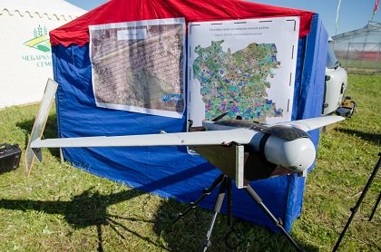
South Ural State University has long been working on creation of unmanned aerial vehicles (UAV). Students of the Faculty of Aerospace Engineering are mastering the techniques for creating such devices and are writing research papers on this topic.
Director of Geoinformation Systems Research and Education Center Valentina Maksimova shares on how data on the Earth and bodies of water are gathered, how the first drone appeared at SUSU, what UAVs are useful for, and how it is possible to study climate using them.
– How are data on the Earth and its surface gathered?
‒ These data are gathered in several ways: the first one is field studies. These investigations are completed in the field, where information is gathered using geodesic equipment, gps, tacheometers. The second method is decryption or identification of satellite images, or analyzing of open data (google maps and Esri). And the third method is aerial photography, which is performed using professional aircrafts or unmanned aerial vehicles.
– How did the first drone appear at SUSU?
‒ The university is working on innovations in UAVs research and development. In particular, the Faculty of Aerospace Engineering has a group of aircraft engineering, where such devices are designed. We couldn’t ignore this fact and we addressed the Faculty of Aerospace Engineering staff for their help in creating a drone. They constructed a few models, which we tested in a pilot project in the Kremenkul village. When larger and more complex works appeared in the center, it became necessary to acquire reliable industrial drones. The copter created at the university was a type of educational model, which was created for an exhibition stand as a visual aid. Without a doubt, it was helpful for us in fulfilling certain projects. But when larger volumes of work appeared, as well as government orders, we had to use more professional UAVs.
– What is the peculiarity of the new aerial vehicles?
‒ As a national research university, SUSU acquired a set of UAVs: 1 copter and 2 planes. The first one is able to hover above an object for 40 minutes to study it and do a 3D model and post it on a web-site. The airplanes, in their turn, can for over two hours film large areas, from 300 to 500 Ha per flight. Of course, a drone has a so-called “shelf life” of about 100-150 flights. After this, to use it again, it needs to undergo technical maintenance, and have the camera calibrated. A drone operates on large electrolytic cells.
– How are these devices helpful?
‒ Using these devices you can monitor the behavior of bodies of water, forests, fields, and urban developments. The application of these devices is very effective, especially when emergencies occur. Drones work in practically any weather conditions, regardless of the strength of wind, fog, rain, and snow. Drones do not lose communication with their operator when they fly away from him. It takes around three months for a drone to study a city and collect photos into a unified picture.
– How do drones study climactic conditions?
‒ Drones can predict the condition of lakes and rivers and analyze the level of their pollution. Using multispectral cameras, we can also assess the condition of the environment and climate. The camera captures the condition of the air and the presence of heavy metals in it.


