Every year, every second Sunday of March a Day of the Workers of Geodesy and Cartography is celebrated in Russia. In SUSU this holiday is celebrated by the employees of Geoinformation Systems Research and Education Center.
The Center deals with creating and filling geoinformation systems: processing of satellite images, creating of orthophotomaps, cartographical materials and digital terrain models.
Every smartphone user can on his/her own appreciate the convenience of geoinformation systems at the simple level: all s/he needs is just open 2GIS or Google maps. Digital maps have long been helping users find a street they need, find their directions around an unknown city, or monitor traffic jams on the roads. But this is just a small part of what you can do using GIS-technologies. GIS allow to optimize and improve work in industry, agriculture, and other sectors of economy.
But every GIS-product, be it a simple map, or a complex 3D-model of the terrain compiled of thousands of images, means hours, days, and even months of hard work and accurate computing. In SUSU part of this work is being performed by Mikhail Begashev, research engineer at Geoinformation Systems REC.
.jpg)
Mikhail is responsible for working with unmanned aerial vehicles and Earth remote sensing. Before creating a map or a digital model, an airborne survey is required. This is the key phase since the final product is developed based on the images obtained as a result of such survey.
The survey is performed using special drones. Today two unmanned aircrafts are at the disposal of the Center: one of a plane type, and the other one of a helicopter type.
The unmanned aerial vehicle of a plane type is used for working at big facilities, when a big area or vast locations require photographing. For example, a roadbed. Such aircraft is launched by a rubber-metal catapult. The principle is the same as in a sling shot.
Once it is launched, unmanned aircraft flies on a high speed following a pre-set trajectory and takes pictures of the location. It is not always possible to photograph the whole facility after one flight.
“The number of flights depends on the scope of work – the area and length if the facility. Also, on what degree of precision is required. The lower the height, the more accurate data are obtained. The higher the craft is flying, the less precise data it obtains, but the bigger the area that the images cover. It all depends on the customer’s requirements – s/he should beforehand indicate either the scale s/he needs, or space resolution of the orthophotomap,” – explains Mikhail Begashev.
.jpg)
.jpg)
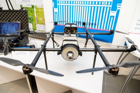
The drone of a helicopter type is used for photographing small facilities, for instance, buildings. It is more maneuverable, so it can fly around the facility and model a high-precision picture, see even every crack on it.
Unmanned aircrafts are operated automatically or semi-automatically. In case of automatic operation Mikhail sets the route and flight details beforehand – orders what and how shall be photographed. That is the main work is done in the office on the computer. All that is needed is to launch the drone at the facility and control that it follows the route. Such principle is used when working with unmanned aerial vehicles of a plane type.
The unmanned aircraft of a helicopter type is operated semi-automatically. For that the operator needs a land based control station consisting of a computer, antenna, send/receive module and a joystick to control the drone. In a real-time mode the station displays both the navigation parameters and the image seen by the drone camera.
.jpg)
Standard cameras available at any electronics store are used for survey. However, before starting to operate them they are synchronized with a GPS-sensor of the unmanned aircraft, in order to trace when, where and in what position a picture was taken.
Depending on the area of the facility the output result may include 100 to several thousand of images. After that, using a special software, those are compiled into a single map or 3D-model.
“The duration of the image render depends on the facility. For instance, a couple of thousand of images may be processed within a day, 100-200 images – over several hours. If there are a lot of images, we contact the SUSU Supercomputer Simulation Laboratory for help. They provide us with additional capacities, and this speeds up the process,” shares Mikhail.
.jpg)
.jpg)
GIS-technologies are used in various fields and make work much easier. For instance, such method is popular during quarrying and mining for mineral resources.
“Using a drone we can take pictures of a quarry once a month, and come up with a 3D-model depicting what part of the resources was covered, and how much ore was produced. Whether works were performed properly. We may even predict a probability of a landfall. All of this considerably reduces the cost of measuring: the surveyor no longer needs to run around with a tacheometer and take measurements manually,” says the research engineer.
According to the researchers’ forecasts GIS will be used more and more widely every year, and that means many of the existing problems will be solved much quicker and at a lower resource expense.


